
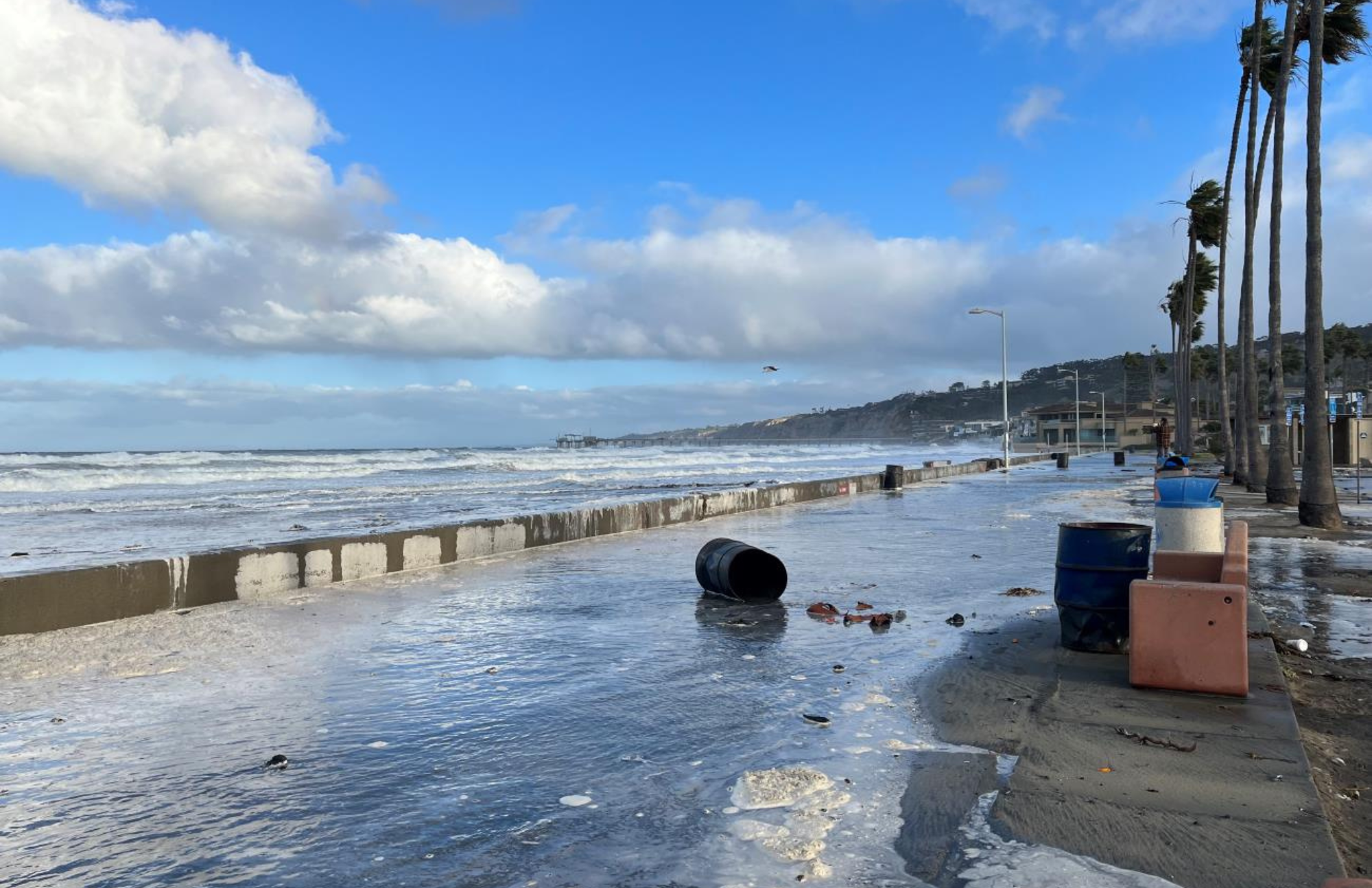
The highest tides of the year, perhaps ever
Each year, the annual king tides provide a dramatic experience along the California coast. High tides of 7 feet or more swallow many of our beaches, giving us a glimpse of our coastline’s future as sea levels rise. They’re the best preview we have of what an ordinary high tide will look like with about a foot of sea level rise, which the state projects by 2050.
This year’s king tides may surpass anything we’ve seen before. A powerful El Niño event, on top of a record-breaking marine heat wave, has pushed water levels as much as a foot and a half above normal. In late October, Southern California tide gauges broke records without any help from king tides, and large swells on top of that have battered coastal communities. Governor Newsom declared a statewide emergency on September 21; at least 8 cities have done so as well. Since late summer, reports of damaged coastal properties, cracking bluffs, flooded streets, and severe beach erosion have come in almost daily.
Now the king tides are arriving on top of all that. They may well produce the highest tides ever recorded along the California coast. If large swells coincide - and it looks like they might - California’s beaches and coastal infrastructure could face a reckoning the likes of which has never been seen before.
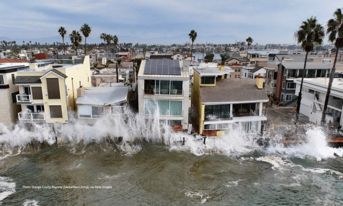 Long Beach. Orange County Register (MediaNews Group) via Getty Images
Today’s extreme, tomorrow’s normal
Most of the media coverage so far contains a climate change-sized blind spot; namely, that events of this magnitude will occur more often in the future.
According to the state’s best available science, California should expect nearly a foot of sea level rise by 2050. For reference, one vertical foot of sea level rise can consume a football field length of beach. Up to 3.1 feet is expected by 2100, but higher amounts cannot be ruled out if we fail to curb emissions and cause ice sheets to melt faster. Long before then, rising seas will amplify high tides, storms and big waves, driving the same rapid increase in beach erosion and coastal flooding that we’re experiencing during this El Niño event.
How our state and coastal communities respond today will decide whether our beaches survive. Emergency declarations only fast-track destructive coastal armoring that sacrifices the beach in order to protect what’s behind it. Surfrider calls upon our leaders to plan ahead for sea level rise now, prioritizing strategies such as nature-based adaptation and infrastructure relocation, instead of through reactive armoring one emergency at a time. Observing and documenting the king tide’s ties directly to this critical work of preserving our beaches now and forever.
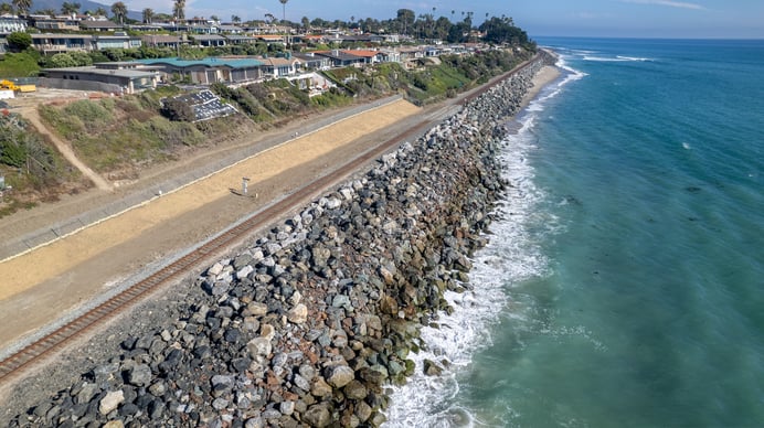 Reactive emergency armoring caused total beach loss in south San Clemente
Observe & document on Nov 24-26, Dec 23-25
For years, Surfrider volunteers have documented king tides to help decisionmakers and the general public visualize how sea level rise will reshape our coastline. This winter, the confluence of El Nino, a marine heat wave, and king tides will bring that future into its clearest focus yet. If there is any silver lining to the beach loss, flooding, and damage we’re seeing, it’s that they reveal how unprepared California for what’s coming. This winter must be a rallying call. The time to plan for sea level rise is NOW.
Therefore, it’s more critical than ever to document king tide impacts. Drone videos and GoPro timelapses are welcome, but most smartphones can capture compelling footage of the high tide, the low tide, or both.
Below is a statewide king tides map from the California Coastal Commission’s King Tides Project. You can use it find out when the high tides peak across the state. The project is the state’s largest public repository of king tide photos, all uploaded by volunteers like you. Surfrider highly recommends uploading timestamped photos there as well. To learn more, check out their “how to participate” page.
Please be sure to review the safety guidelines below before heading out!
The lowest tides too
We’d be remiss not to mention that king tides go extreme in both directions. As sunset approaches, the tides will recede to a negative low that reveals the widest, most walkable beaches of the year. If possible, we recommend returning to the same spot you documented the high tides and documenting the low tides as well. These are the most dramatic tidal swings of the year.
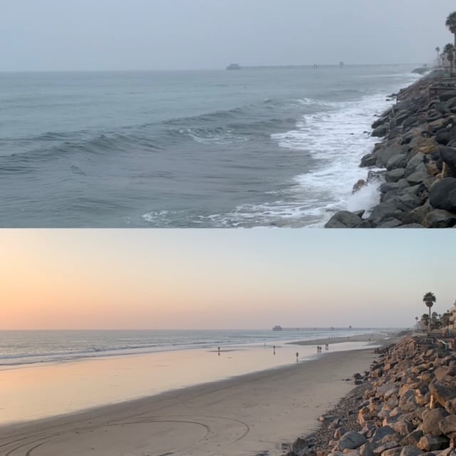 Oceanside tidal swing, 2021 (Halei Young)
How to document the king tides
Video footage and photos are both welcome. Here are some helpful guidelines to make the most of your documentation.
- Arrive within 30-45 minutes of the high (and low) tides.
- If you're using a phone, please capture footage in both portrait and landscape mode. If you have to choose one, we recommend the horizontal/sideways position to optimize a wide angle that is better for YouTube-style videos.
- For video, we typically use snippets between 3-15 seconds long.
- For the HIGH TIDE, we're looking for:
- Beach loss in areas where beaches usually exist during normal tide conditions.
- Flooding of coastal infrastructure, e.g. the ocean breaching onto roads, walking paths, parking lots, lifeguard towers under water, etc.
- Waves overtopping any infrastructure (private property, roads, access paths, etc.).
- Footage needs some land-based reference to be compelling - parking lot, riprap revetment or seawall, lifeguard tower, beach access staircase, etc. It's difficult to gauge the king tide effect if footage only shows waves washing ashore on a sandy beach without references.
- Please be mindful of your safety and keep a safe distance from the observed high tide line (especially if there is a good swell that day). Never turn your back to the ocean. Safety first!
- If you're able to capture both high and low tide footage, please return to the same spot in the afternoon to capture low tide images. It will be worth it as you'll be able to stay for sunset!
Once you’re ready to share your footage with Surfrider, please email yours truly at msilverstein@sufrider.org. I’ll provide you with an upload link.
What's a king tide anyway?
King tides are, quite literally, a cosmic phenomenon. Our daily tide swings are caused by the gravitational pulls of the moon and the sun. They become strongest during a full or new moon, when the sun, moon, and Earth align. These larger tide swings, which typically occur twice a month, are referred to as 'spring tides.' However, when the moon is at its closest position to Earth (or "perigee") during a spring tide, it's called a 'perigean spring tide.' King tide is a non-technical term for perigean spring tides. If you'd like to geek out on this even more, check out NOAA's website HERE.
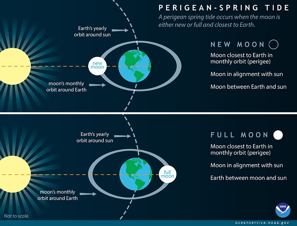 Source: NOAA
An important note on safety
King tides offer our best preview of sea level rise, but they also present potential hazards. This is especially true when combined with intense storms and large waves, which is a definite possibility. Please do not risk your life to observe or document the king tides. Keep these safety tips in mind, borrowed verbatim from the California King Tides Project.
- Check weather, surf, and tide conditions. Before heading to the coast check local weather forecasts, surf advisories, and tide charts to know when tides in your area are rising and receding. Obey cones, caution tape, and closure signs.
- Plan your route and know your exits. High tides can completely submerge beaches and coastal access points. Identify safe routes to and from the shore to prevent getting trapped between advancing water and steep cliffsides. Be aware of cliffs, bluffs, and other areas that may become unstable.
- Know your location. Note the name of the beach, the nearby lifeguard tower numbers, and any posted access signs. In the event of an emergency call, these could become important details for operators and first responders.
- Wear appropriate shoes and watch your footing. Choose closed-toed shoes with good traction and move cautiously on wet or uneven surfaces. Avoid climbing on unstable logs and rocks, which can become very slippery when wet.
- Keep a safe distance from the water. Never turn your back on the ocean and stay a safe distance from the water. Standing on rocks, seawalls, or bluff edges can be particularly dangerous as powerful waves may emerge without warning, sweeping unsuspecting adults, children, and pets into the ocean in an instant.
- Stay alert even at low tide. King Tides also create extremely low tides, making tide pools and sea caves tempting to explore. However, conditions can quickly change, “sneaker waves” can surge unexpectedly, and rising water can trap you in hazardous areas. Check your tide chart and make sure you’re not in a dangerous area when the tide starts rising.
- Avoid flooded roads. King Tides, especially when coupled with storm conditions, may submerge roads and parking lots. Avoid driving through flooded areas as vehicles can quickly become trapped in dangerous conditions. Saltwater can damage vehicles, including engines and electrical systems. Turn around. Don’t drown.
 Mitch served in various volunteer leadership positions with the San Diego Chapter before being hired on as Chapter Manager in 2018. In 2022, he transitioned to the chapter’s policy role. In 2025, he's broadened his scope as California's Senior Policy Coordinator.