While Sea Level Rise (SLR) will gravely impact California’s coastline, it is growing more apparent that if we give our sandy beaches space to move into they may not vanish as quickly as previously thought. California can appropriately plan for and mitigate the impacts of SLR on sandy beaches with the help of appropriate climate change modeling and smart adaptation planning.
There are many contrasting opinions about how SLR will affect California’s coastline in the future, from reserved to extreme, and there is much debate surrounding which direction should be taken when determining appropriate climate change planning methods. A recent paper by Vousdoukas et. al stated boldly that by the end of 2100 nearly half of the world’s sandy beaches will disappear due to SLR. This prediction was based on Brunn's rule, which assumes that all sand removed from an upper beach profile is redeposited offshore, causing sandy beaches to succumb quickly to SLR. However, an international team of climate scientists disagreed with this statement by claiming that the underlying methodology that produced these results was based on an inappropriate theory and incomplete data sets.
The international team found that this type of SLR modeling can be potentially damaging to climate change planning efforts because local and regional factors must also be considered, including the topography, geomorphology, and sediment transport type that can impact the sandy beaches’ response to rising sea levels. Cooper et. al points out that the underlying premise of the findings by Vousdoukas et. al is reliant upon a flawed model which states that SLR causes offshore sediment transport. While this is the case with some steep sandy beaches backed by coastal cliffs or seawalls, overall most SLR causes onshore sediment transport, changing the position and depth of sandy beaches but not causing them to vanish.
Even as sea levels continue to rise and shorelines retreat, most sandy beaches will continue to remain if there is adequate space for the beach to move into, referred to as “accommodation space.” The sandy beach will be able to hold its shape and form, just in a landward position. This is the case for sand dunes, low-lying coastal plains, and salt marshes.
Since the mid 1980’s the Surfrider Foundation has successfully campaigned for a managed shoreline retreat approach to Sea Level Rise at Surfer’s Point in Ventura. The Managed Shoreline Retreat Project relocated the beach’s bike path, parking lot and pedestrian path away from the shoreline. Instead of constructing a seawall or coastal barrier, which would almost certainly destroy the surf break and cause unnecessary coastal erosion, Surfrider volunteers have planted native vegetation within existing sand dunes and bioswales. This natural barrier provides the sandy beach space to move onshore as a result of SLR.

Both the recreational needs of the community as well as the vitality of the sandy beach have been restored due to smart climate change adaptation planning. By evaluating where more accommodation space can be made along our coasts, properly managed shoreline retreat planning has the ability to save our sandy beaches.
Beaches without accommodation space, such as shorelines dominated by rigid coastal cliffs or engineered structures such as a seawall or dense urban development will disappear the fastest, due to the inability of the beach to travel inland.
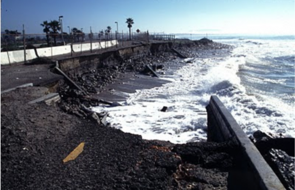
While some of these sandy beach backdrops are naturally occurring, seawalls pose a difficult dilemma when it comes to SLR planning. These seawalls allow little space for the beach to migrate, and almost always increase beach erosion. One example of this is Solana Beach in Encinitas, which is backed by numerous seawalls and retention structures intended to protect private properties from coastal erosion due to high wave energy. With rising sea levels, these beaches will gradually decrease in width, experiencing what is called “coastal squeeze,” and eventually become completely submerged. Because these beaches are the most vulnerable to SLR it is important to approach SLR mitigation efforts more aggressively in these areas.

Photo courtesy of Eduardo Contreras, The San Diego Union-Tribune
California’s coastline is extremely diverse ranging from rolling sand dunes to dense urban development to robust coastal bluffs. SLR will persist and affect varying seascapes in dramatically different ways. The importance of topographical data in adaptation planning cannot be stressed enough. By properly mapping California’s coastline and its geomorphology, there is hope for more accurate SLR planning and adaptation. California’s Ocean Protection Council is currently undertaking a large scale mapping project of California’s shoreline. The project utilizes state of the art remote-sensing techniques to create the most detailed map of the California shoreline ever produced.
Reliable SLR modeling is imperative to the protection of California’s coast, including proper geospatial data, sea level rise rate predictions, and local and regional surveys. Once we can properly predict the response our local coasts will have to SLR we can take an individualized approach to actively mitigate the effects of rising seas and keep ourselves educated and prepared for the future ahead.
A future of Sea Level Rise is inevitable, however the ways in which we act now and prepare for these challenges can make all the difference. Armoring our coasts with seawalls and fortified barriers almost certainly ensures a rapid rate of coastal erosion and the disappearance of our sandy shores. Our sandy beaches have a chance of survival if we prepare for the climate crisis now and provide our beaches accommodation space to move into. There is hope for our coastline if we approach Sea Level Rise planning with informed decision making and collaborative efforts.